My last hike of the year is an attempt at a grand slam: to climb Mt. Ida, Chief Cheley, Cracktop, Mt. Julian and Terra Tomah in one day. Of course this is quite ambitious, and I know I may not make it. Last year I tried the same thing and quit at Mt. Ida; I didn't get up Ida until almost noon, didn't feel good, and the weather didn't look good. This year I hope to do better.
| I decide to approach Mt. Ida from Timber Lake because my log book shows that I climbed Ida faster from Timber Lake than from Milner Pass. I'll need an early start to bag this set of peaks. I get a camping permit for Snowbird campsite, the highest campsite just below Timber Lake. I leave the Timber Lake trailhead at 17:40. It has been raining as I drove over Trail Ridge Road, and it soon begins to sprinkle on me as I hike. Not a good sign. I decide to press on. This may turn out to be a soggy campout followed by a retreat in the rain tomorrow, but it's my last chance for a big hike on this year's vacation. I reach the Long Meadow junction (1.7 miles to go) at 19:32. I stop by the privy 1/2 mile below the lake and then head on, walking right by the campsite (the sign being behind a bush) and getting to Timber Lake at 20:40. I have to backtrack to find the campsite. |  |
There are two campsites at Snowbird. Whoever is camped at the other one has thoughtfully hung their bear bag at my site, so that I can host the bear. How nice. Probably they thought nobody would camp here tonight. I hang my bag next to theirs and go off to pump some water in the near-darkness, eat dinner, and get to bed at 22:05. It is cold this night, and I pull the mummy bag tight around my face, then sleep soundly.
I set the alarm early and get up at 05:05 and get moving by 06:15. I stop near Timber Lake and pump some water, only to have my pump fail after a few quarts. Later analysis shows that the input tube is clogged: Timber Lake is swampy, and the stream below it has much more filter-clogging junk than most. I give up on the pump filter, but I've got to have water. I carry iodine tablets as a backup, but have never used them, and I note that they expired last year. I use two tablets per quart and expect to let it sit for quite a while, so I hope it will be okay; if I get sick, it will be well after my hike is over. I put moleskin on my feet, since I have some near-blisters from my last hike, put on sunscreen, and start really hiking at 07:15.
As I start up to the saddle above the lake, I cache my sleeping bag, pad, and bivy sack behind a rock. Naturally I choose a place where it can be seen from far away and where I will have to pass it on the return. The climb to the saddle is steep and the talus often loose; this part of the hike was a struggle last year, and it feels that way now also. I reach the saddle at 08:52 (my goal for the Ida summit was 09:00) feeling rather tired.
| The weather is good, with thin cirro-stratus clouds and calm wind. I continue up the more gentle grassy slopes to the summit of Ida at 10:12. I take some photos and rest, then leave, down the southeast ridge of Ida toward Chief Cheley. This ridge is steep, but the rock is fairly solid, and it is easy climbing going down and up, with some third class. One problem with this hike is that it involves climbing five mountains, then re-climbing the first four to get back, so I am going to have to climb back up this steep ridge when I am tired. |  |
Although the west side of the peaks is completely dry, there are some accessible snowbanks just east of the ridge at the bottom of the saddle between Ida and Chief Cheley. Thinking that I may need more water on the way back, I fill several large Ziploc bags with snow and throw them down on dark rocks to melt while I hike. The ascent of the ridge of Chief Cheley is uncomplicated, and I reach the summit at 12:08. There is no summit register that I can find on Chief Cheley. The summit of Cheley is white rock, a fitting crown for a Chief. I hear shouts of hikers on Mt. Ida (probably a victory cheer) and wave to them.
| At 12:45 I leave Chief Cheley, heading south along the Continental Divide. There is some third-class scrambling to get down Cheley, then easy walking along the relatively flat divide. I circle around a cirque for half a mile toward Cracktop. Highest Lake is striking, with ice still floating on it. I climb east up a narrow and not very long ridge to the summit of Cracktop at 13:36. Eight people have climbed Cracktop in the past year. One, a ranger, wrote of having the world's best job (being paid to hike) and expressed surprise that nobody had climbed Cracktop yet that year. There are some dark clouds. |  |
I recommend Mark Twight's book Extreme Alpinism. (When my family accuses me of being crazy for climbing mountains, I can always point to Twight as far more crazy than I am.) Twight recommends eating Gu for energy, and I have decided to try it. Gu is maltodextrin, a sugar polymer that is slowly digested into glucose for energy. I'm not a big fan of the taste -- not bad, but bland and artificial. A few years ago, a raccoon got into our car; it ate all the beef jerky, and all the granola bars, but after biting into one packet of Gu, it left all the Gu. However, I find that on a hike, my stomach shuts down and I don't feel like eating anything. I can squeeze a packet of Gu into my mouth and swallow it directly, and it doesn't bother my stomach the way food would. Eating the Gu seems to be helping on this trip.
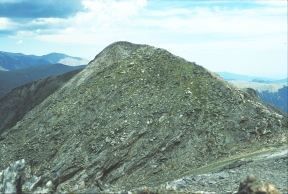
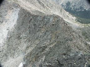
| I leave the summit of Cracktop at 14:05 and head toward Mt. Julian. This is the crux of the trip: this ridge is more rugged and exposed than anything else on this route. I go onto the south side of the ridge, which is steep but with various grassy ledges a meter wide. I am doing okay climbing down this, but I wonder: will I do as well climbing back up it, and will I remember the route? At 14:55 I stop to rest and survey the remaining ridge. It looks like another hundred meters or two of this steep but doable climbing may get me into easier territory. I have set a desirable turnaround time of 16:00 and an absolute turnaround time of 17:00, in order to be back on top of Ida by 21:00 and darkness. It doesn't look like I can climb Julian, much less Terra Tomah, in that time, so I turn around. I note, however, that dropping into a mild valley, next to a triangle-shaped minor peak half a mile south of Cracktop, looks like a more reasonable way to climb Julian; that may be a route for next year. |  |
|
I reach the summit of Cracktop again at 15:12. The view of Chief Cheley and Highest Lake is spectacular. I leave at 15:30, and reach Chief Cheley again at 16:25. I leave Chief Cheley at 16:45 and get back to the Ida-Cheley saddle at 17:07. I should have some bags of water from my melted snow, but I am disappointed. High-altitude rocks are often sharp, and throwing the bags down on the rocks has cut holes in the bottom. One bag appears to have been munched by a rodent. Almost all the water has leaked out. I drink what little water there is in one bag and stuff them back in my pack; I'm lucky they didn't blow away. |  |
|
Now I have to re-climb Mt. Ida to get home. Although I am tired, it isn't too bad, and I reach the summit at 17:47, then head carefully down on increasingly sore feet. I reach the saddle above Timber Lake at about 18:30. The steep descent to Timber Lake on loose talus is slow to avoid injury. I have an uncomfortable feeling: I remember this route, but from last year, not this morning. Where is the stuff I cached? While it seemed like I cached it on the only possible route this morning, there seem to be many routes now. I have to wander around near the bottom for a while before finding my cache intact. I reach Timber Lake at 19:45, go squishing around its swampy banks, and head on down. I make a pit stop at the open-air privy half a mile below the lake, providing an opportunity for the mosquitoes. |  |
It soon gets dark, and I walk down the trail using a Petzl Tikka LED headlamp. It isn't very bright, so I have a flashlight in my pocket as backup, but the headlamp is adequate. My feet hurt quite a bit, but I hurry down the trail as much as I can, reaching trailhead at 22:00. A drive back over Trail Ridge Road, passing about ten cars heading the opposite direction at this late hour, and hitting innumerable miller moths, gets me back home about midnight.
This hike is very enjoyable, with spectacular scenery and solitude.