I leave the Glacier Gorge trailhead at 5:43, arriving at Mills Lake an hour later. It is cool and windy, with the sun just coming over the ridge and illuminating the mountains on the east side of Glacier Gorge.


|
McHenry's Peak is considered by some to be the hardest non-technical peak
in Rocky Mountain National Park. It certainly is an interesting climb.
I leave the Glacier Gorge trailhead at 5:43, arriving at Mills Lake an hour later. It is cool and windy, with the sun just coming over the ridge and illuminating the mountains on the east side of Glacier Gorge. |  |
| I continue toward Black Lake over a less developed trail, passing below Arrowhead, arriving at Black Lake at 8:15. Black Lake sits below a broad, relatively flat bench several hundred feet high that surrounds it on three sides. There are two ways up onto the bench -- west toward McHenry's over sloping and exposed slabs, or east up the inlet creek. After looking at the west approach and not seeing an obvious good route, I choose the safe route up the creek, reaching the top of the bench at 9:05. Then there is simply a hike past Spearhead across the bench toward McHenry's, with patches of nasty bushes to be avoided; there is a clear view of Stone Man Pass and McHenry's Peak. I stop at the creek below Frozen Lake to filter water for the summit climb. |  |
 |
 |
| The approach to McHenry's Peak from Glacier Gorge is via Stone Man Pass, which lies at the bottom of the ridge of McHenry's (north of the pass) not far from a pillar called the Stone Man (it looks more like a stone man's male organ). The pass is not next to the Stone Man, but next to the ridge, to the north of Stone Man. For the first half of summer, the approach to the pass is covered by moderately steep snow (perhaps 35 degrees). [Gerry Roach's book says this snow has a reputation for avalanching in early summer, so the route is not recommended before June 15.] I arrive at the start of the snow at 11:15 and start up, using crampons and an ice axe self-belay, and reach the pass at 12:30. |  |
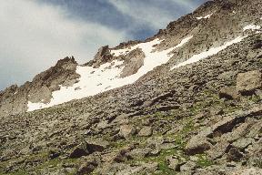
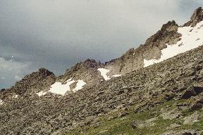
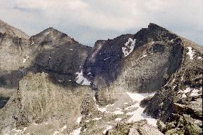
| The west side of McHenry's has a large rock rib running all the way up it. There is also an intermediate rib, followed by a couloir; it is necessary to cross the rib and couloir to reach the summit. Some guidebooks suggest descending slightly to the west from Stone Man Pass and contouring around to find a gap in the rib; even after seeing it, photographing it, and re-reading the descriptions, I don't see where this route is, though it is supposedly well cairned. Other books say the easiest route is straight up the ridge, and I'm inclined to agree; that is the way I go. Four photos can be overlaid to show the complete west face area from Stone Man Pass: upper rib and ridge, upper middle rib, lower middle rib, lower rib. |  |
 |
 |
 |
The climb up the west side of the ridge from Stone Man Pass is on talus that is generally large, stable, and well-textured, so it is good climbing. As I near the top of the ridge (a false summit), the climbing becomes uncomfortably steep, and I begin to look around for a better way. I see slightly below what looks almost like a trail to the north onto the rib, and I decide to go that way and see if it is a good route. The route crosses a knife-edge ridge about 20 feet long, perhaps exposed on the east side, but with good hand and foot holds, and I cross it without difficulty. The trail does not go through the rib, but contours around it (this is a smaller rib near the top) and leads into a couloir below the summit. The couloir is steep and would be dangerous if snow-filled earlier in the season. |
| It looks possible to go directly toward the summit from here (steep 3rd class) or to cross the couloir for 3rd class climbing that looks a bit less steep; I traverse across the couloir below a snowfield. The climbing is steeper than it looked, with one section that requires several linked moves and takes me 10 or 12 feet off the deck, more than I would like; I get up it okay but am not sure I could downclimb it comfortably. From there, the going is less steep, and it tops out on the summit ridge, which I reach at 14:57. It might be possible to traverse farther beyond the couloir to the ridge beyond for less-steep climbing. |  |
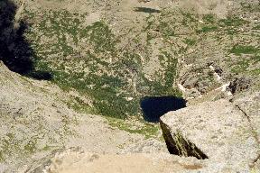
| The summit is a boulder on top of a small, relatively flat ridge. Although the summit is quite dry, the summit register is sopping wet and can't be written on. There is a sheer drop off the east side and a view straight down to Black Lake. There is a fine view of Longs Peak, Pagoda, and Chief's Head. Storm clouds are threatening, so I leave hastily at 15:25. Going down, I head straight south down the ridge from the summit over the 3rd-class rocks shown in the earlier photo; this is steep and requires some planning of moves and small traverses to easier spots, but works out okay. |  |
 |
 |
| This takes me to the same "trail" I used on the way up, with a traverse back over the knife-edge ridge, then down talus to Stone Man Pass at 16:25. There are a few lightning bolts within a fraction of a mile. |  |
| At the pass it is beginning to sprinkle; I put on crampons and start down, again using an ice axe self-belay (thrusting the shaft of the axe vertically into the snow ahead of each pair of steps, while holding onto the head of the axe and using a wrist leash). I am plunge-stepping into my previous footprints for traction, but at one point my feet slip and in an instant I am sprawled face-down on the snow, holding onto the head of the ice axe with both hands. The axe twists some 45 degrees from the vertical in the snow, but it holds. Given the steepness of the snow and the speed with which I slipped, it might have been hard to self-arrest, so I would definitely recommend the ice axe self-belay for this snow. |  |
At the bottom of the snow it begins raining; rain isn't much fun to hike in, but it has been so dry that aspen trees along the trail have dropped all their leaves and have probably been killed, so any rain is welcome. I see and hear a few people who appear to be camping below Spearhead; aside from Spearhead climbers, I haven't seen anyone today. Going slowly to avoid slipping on the wet rock, I reach trail at Black Lake at 18:25 and the trailhead at 21:10. My feet are sore, but it has been a great hike. Total water consumed 5 qt.